
Leica Total Stations: High-Precision Surveying Instruments for Professionals|Top Server


Leica Total Stations: High-Precision Surveying Instruments for Professionals
Leica Geosystems’ total stations are advanced surveying instruments that integrate electronic theodolites and distance meters to capture highly accurate spatial data. Engineered for precision and reliability, Leica total stations are designed for demanding field work – from simple boundary surveys to complex engineering projects. Modern Leica models offer sophisticated on-board software (e.g. Leica Captivate) and touchscreen interfaces, making data collection intuitive for surveyors and engineersaaisurvey.comcaliffsurveying.com. These instruments consistently deliver sub-millimetre accuracy even in harsh environments. For example, the top‑end Leica Nova TS60 achieves 0.5″ angular accuracy and 0.6 mm + 1 ppm distance accuracycaliffsurveying.com, enabling exceptionally precise results. At the same time, Leica emphasizes durability and ease of use: its manual FlexLine series focuses on “the highest quality… and the longest durability in the industry”kukerranken.com. Equipped with bright displays, ergonomic controls, and features like LED guide lights, Leica total stations streamline workflows and help users stake out points more quicklyaaisurvey.comkukerranken.com.

Leica total stations (as shown) combine a survey instrument and controller for efficient on-site data collection. Leica’s robotic models, such as the iCON iCR80, leverage patented ATRplus auto-aiming and long-range Bluetooth for seamless operation. For example, the iCR80 offers “stable data communication with long-range Bluetooth® (up to 400 m)”kukerranken.com, enabling wireless data transfer between the instrument and handheld controller across large sites. This connectivity – along with options for USB, SD, and Wi-Fi – allows survey teams to quickly move data between the field and officeaaisurvey.comkukerranken.com. Advanced models also integrate GNSS and digital imaging: for instance, the Leica Nova MS60 “combines an intelligent total station, digital imaging, GNSS connectivity and 3D laser scanning in a single instrument”pure-surveying.com. In practice, these smart technologies maximize productivity and reduce manual errors. Automated features like ATRplus (automatic target aiming and re-locking) and Dynamic Lock keep the instrument fixed on a moving prism, so one operator can layout points efficiently without interruptionkukerranken.comcaliffsurveying.com. On-board Leica software (Captivate or FlexField) provides guided workflows and real-time 3D visualization, turning complex data into usable models on the spotcaliffsurveying.comaaisurvey.com. Overall, these innovations – from touchscreen interfaces to long-range wireless links – make Leica total stations exceptionally user-friendly and productive for field professionals.
Key Features
- Precision and Accuracy:
Leica total stations deliver industry-leading measurement precision. High-end models achieve sub-second angular accuracy and sub-millimetre distance accuracycaliffsurveying.com. Even mid-range Leica instruments provide excellent accuracy (for example, the TS07 FlexLine offers ~1.0 mm + 1.5 ppm distance accuracyaaisurvey.com). This level of precision ensures survey points are captured with minimal error, which is crucial for engineering layouts and boundary surveys. - Durable Construction:
These instruments are built to withstand tough field conditions. Leica’s FlexLine series, for example, is reputed for “the highest quality… and the longest durability in the industry”kukerranken.com. Leica notes that even after years of use in harsh environments – mud, dust, blowing rain, extreme heat or cold – the instrument “still operates with the same high level of accuracy and reliability”kukerranken.com. Rugged, weather-sealed housings (typically IP-rated for dust/water resistance) and robust optics help Leica total stations continue performing reliably in challenging sites. - User-Friendly Operation: Leica designs prioritize operator efficiency. Large color touchscreens, physical keypads, and optional electronic guide lights (EGL) make setup and stakeout fast. On-board software (such as Captivate) provides intuitive apps and graphical interfacescaliffsurveying.comaaisurvey.com. Guided workflows and a familiar Leica menu system mean surveyors spend less time learning the instrument and more time measuring. As one Leica distributor notes, users can “work faster by measuring more points per day with less measurement errors and rework”kukerranken.com. Long battery life (often 20–30+ hours) and features like auto height setup also reduce downtime in the field.
- Wireless Connectivity:
Leica total stations offer multiple data transfer options. Besides traditional cables and memory cards, most models provide Bluetooth® and Wi-Fi capabilityaaisurvey.com. This lets field crews send measurements directly to handheld controllers or even to the office network in real time. Leica’s field controllers (e.g. CS/CC series) support these links along with 4G/LTE mobile data. Such connectivity ensures that point coordinates and plans flow quickly into survey software, improving collaboration and reducing transcription errors. - Robotic and Automated Features:
Leica’s robotic total stations excel at one-person operation. Technologies like ATRplus auto-targeting automatically lock onto a prism and re-lock if sight is brokenkukerranken.com. The Dynamic Lock feature further enhances this by tracking moving prisms continuously, which is valuable for machine control or staking moving targetskukerranken.comcaliffsurveying.com. Combined with Leica’s PowerSearch function for rapid prism acquisition, these features let an operator quickly lay out complex designs without a second person. - Integrated 3D Scanning:
Certain Leica models (often called “multi-stations”) add laser-scanning capability. For instance, the Nova MS60 can capture up to 30,000 points per second as it measures, effectively merging total station surveying with 3D point-cloud capturepure-surveying.com. This all-in-one functionality streamlines tasks like detailed building documentation or topographic mapping, where both precise coordinates and dense spatial data are required.Applications
Leica total stations are essential tools in surveying, construction, engineering, and mapping. Surveyors trust them for boundary and topographic surveys, as their high precision yields reliable site datacaliffsurveying.comkukerranken.com. In construction, Leica instruments are used for layout of foundations, building corners, roads and utilities. For example, during building construction and civil engineering projects, Leica notes that surveyors can tackle “most survey and layout tasks” easilykukerranken.com. Tasks such as stakeout of footings, alignment of structural elements, and as-built verification are all accelerated by Leica’s quick measurement speeds and automation.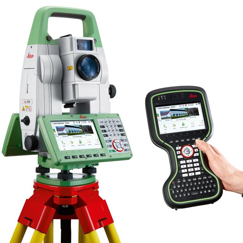
Surveyors commonly use Leica robotic total stations for construction layout and infrastructure projects. In road and bridge construction, these instruments guide machine control and stakeout with high accuracy. In infrastructure and mapping projects, Leica total stations collect precise data for roads, railways, pipelines, and power lines. The instruments integrate smoothly with GIS/BIM workflows. They can be used to capture control networks and detailed topographic maps that feed into planning software. Leica total stations are also employed in specialized fields like mining surveys, environmental monitoring and GIS data collection – anywhere high-precision distance and angle measurements are needed. Overall, these instruments serve professionals across land development, urban engineering, and even research applications, thanks to their accuracy and versatility.
Why Choose Top Server
Top Server is a leading supplier of Leica total stations and surveying equipment in Pakistan, backed by decades of industry experience. The company highlights its expertise and reputation: as a “pioneering civil engineering and survey instruments provider,” Top Server has built “a reputation for excellence” with “unmatched service and expertise” nationwidesurveyinstruments.info. With over 30 years in business, Top Server is described as a “trusted partner” offering premium, reliable instruments along with authorized service supportsurveyinstruments.info.
- Decades of Experience: Since 1993, Top Server has specialized in high-precision survey tools. Their long history means they understand local project needs and conditions. Top Server emphasizes that customers benefit from its “30 years of expertise” and commitment to premium equipmentsurveyinstruments.info.
- Authorized Service & Support: Top Server maintains factory-authorized support for the instruments it sells. In Karachi, the company’s certified workshop provides calibration, maintenance and repair to keep Leica total stations in “optimal condition”surveyinstruments.infosurveyinstruments.info. Top Server notes it offers “professional, authorized service that…extends the life and performance of your high-tech survey instruments”surveyinstruments.info, ensuring longevity of customers’ investments. Routine servicing and updates from Top Server help maintain the full accuracy of Leica instruments throughout their lifetime.
- Purchase, Rental and Demonstrations: Top Server offers flexible options for acquiring Leica equipment. Customers can buy or rent total stations as needed – for short-term projects or long-term use. In fact, the company highlights that whether you’re “purchasing or renting,” it is the “go-to source for…top-quality survey products”surveyinstruments.info. Top Server also provides on-site demonstrations and training upon requestsurveyinstruments.info, so users can fully understand Leica’s advanced features before committing. These services make it easy for survey firms and engineers to select the right Leica model for their workflow.
- Trusted in Pakistan’s Surveying Industry: Top Server’s clientele includes government agencies, major construction firms, engineering leaders and consulting expertssurveyinstruments.info. The company’s authorized partnerships (with top global brands) and extensive support network give confidence that buyers are getting genuine Leica equipment and reliable after-sales care. In sum, Top Server combines global-quality Leica total stations with deep local knowledge: as they state, their mission is to ensure instruments “perform flawlessly, every time” through premium products and dedicated service.
Conclusion
Leica total stations bring together precision optics, durable design, and cutting-edge automation to meet the most demanding surveying, construction and mapping tasks. Their sub-second accuracy and robust electronics translate to faster, more reliable survey data, reducing errors and rework. Equipped with smart field controllers, wireless links, and advanced software, Leica instruments greatly enhance field productivity. For professionals in Pakistan, Top Server provides the ideal support for Leica solutions. With decades of experience and an emphasis on service excellence, Top Server makes it easy to purchase or rent the latest Leica total stations. Their authorized workshop and technical expertise ensure every Leica instrument is well maintained and ready for the field. In partnership with Top Server, surveyors and engineers can rely on Leica total stations to deliver top-tier performance – making Top Server the go-to source for high-precision surveying equipment in Pakistan.
Contact Us :
Instagram : @topserverpk
Facebook : Top Server
Linkedin : Top Server
WhatsApp : +92 332 2491691 +92 334 3738461
( WE ARE JUST A TEXT AWAY)